


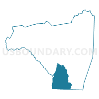
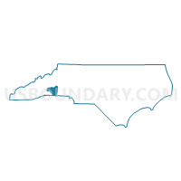
Voting District 09A, Rutherford County, North Carolina
About
Outline

Summary
| Unique Area Identifier | 641367 |
| Name | Voting District 09A |
| County | Rutherford County |
| State | North Carolina |
| Area (square miles) | 46.06 |
| Land Area (square miles) | 46.00 |
| Water Area (square miles) | 0.06 |
| % of Land Area | 99.86 |
| % of Water Area | 0.14 |
| Latitude of the Internal Point | 35.23140150 |
| Longtitude of the Internal Point | -81.90687680 |
Maps

Graphs
Select a template below for downloading or customizing gragh for Voting District 09A, Rutherford County, North Carolina


Neighbors
Neighoring Voting District (by Name) Neighboring Voting District on the Map
- Voting District 05A, Rutherford County, NC
- Voting District 13, Rutherford County, NC
- Voting District 19, Rutherford County, NC
- Voting District 29, Rutherford County, NC
- Voting District 30, Rutherford County, NC
- Voting District 34, Rutherford County, NC
- Arrowood Baptist Voting District, Spartanburg County, SC
- Colley Springs Baptist Voting District, Spartanburg County, SC
- Voting District GC09, Polk County, NC
- Morgan Voting District, Cherokee County, SC
Top 10 Neighboring County Subdivision (by Population) Neighboring County Subdivision on the Map
- Cool Spring township, Rutherford County, NC (14,804)
- Rutherfordton township, Rutherford County, NC (13,107)
- High Shoals township, Rutherford County, NC (8,363)
- Macedonia CCD, Cherokee County, SC (7,713)
- Chesnee CCD, Spartanburg County, SC (6,382)
- Sulphur Springs township, Rutherford County, NC (5,133)
- Green Creek township, Polk County, NC (3,607)
- Union township, Rutherford County, NC (1,824)
Top 10 Neighboring Unified School District (by Population) Neighboring Unified School District on the Map
- Rutherford County Schools, NC (67,810)
- Spartanburg School District 2, SC (58,308)
- Polk County Schools, NC (20,510)
Top 10 Neighboring State Legislative District Lower Chamber (by Population) Neighboring State Legislative District Lower Chamber on the Map
- State House District 112, NC (75,804)
- State House District 113, NC (75,113)
- State House District 38, SC (37,612)
- State House District 30, SC (34,013)
Top 10 Neighboring State Legislative District Upper Chamber (by Population) Neighboring State Legislative District Upper Chamber on the Map
- State Senate District 48, NC (193,127)
- State Senate District 46, NC (165,888)
- State Senate District 11, SC (101,438)
- State Senate District 14, SC (98,937)
Top 10 Neighboring 111th Congressional District (by Population) Neighboring 111th Congressional District on the Map
- Congressional District 4, SC (770,226)
- Congressional District 5, SC (767,773)
- Congressional District 11, NC (703,606)
- Congressional District 10, NC (689,468)
Top 10 Neighboring Census Tract (by Population) Neighboring Census Tract on the Map
- Census Tract 9605, Rutherford County, NC (8,018)
- Census Tract 9701, Cherokee County, SC (7,713)
- Census Tract 9609, Rutherford County, NC (5,330)
- Census Tract 9612, Rutherford County, NC (4,730)
- Census Tract 223.04, Spartanburg County, SC (4,433)
- Census Tract 9604, Rutherford County, NC (3,448)
- Census Tract 9201.01, Polk County, NC (3,373)
- Census Tract 9611.02, Rutherford County, NC (3,349)